Indian Geography
Indian Geography Quiz covers The Physical Geography of India, Locations, Indian Climate, Soils, Indian Flora and Fauna, Indian Economic and Human Geography, map-based questions.

1. The Radcliffe Line is the international border between
(A) India and Pakistan
(B) India and China
(C) India and Nepal
(D) India and Bangladesh
Show Answer
Correct Answer: (A)
Explanation:
About Redcliffe Line
- It was the line 3323 km long demarcated between India and Pakistan, published on 17 August 1947.
- It was named after Cyril Radcliffe, who was the chairman of the boundary commission.

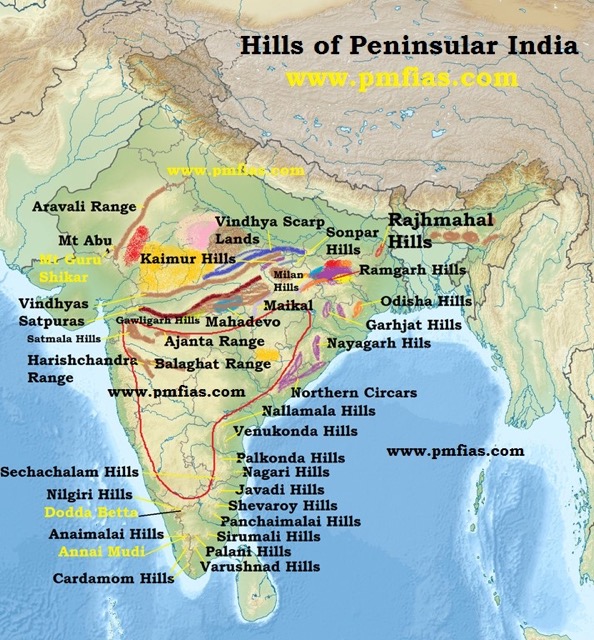
2. Arrange the following hills of Peninsular India from North to South:
- Ajanta Range
- Kaimur Range
- Maikal Hills
- Shevaroy Hills
Select the right code:
(A) 1-2-3-4
(B) 2-1-3-4
(C) 4-1-3-2
(D) 2-3-1-4
Show Answer
Correct Answer: (D)
Explanation: You should have a look at all the hills. In the exam, any hill may be asked to arrange.
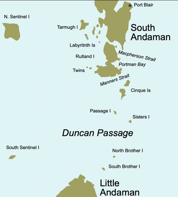
3. Duncan Pass is located between
(A) South and Little Andaman
(B) North and Middle Andaman
(C) North and South Andaman
(D) Andaman and Nicobar
Show Answer
Correct Answer: (A)
Explanation:
4. Which of the following will never get the vertical rays of the sun
(A) Thiruvananthapuram
(B) Chennai
(C) Mumbai
(D) Srinagar
Show Answer
Correct Answer: (D)
Explanation: Sun rays vertically reach up to 23º27‘. And Srinagar is above that line.

5. Consider the following statements regarding rivers:
- Alaknanda river has its source in the Satopanth glacier.
- Ghaghara river originates in the glaciers of Milam
- Sarda river rises in the Mapchachungo glacier in the Nepal Himalayas.
Which of the statements given above is/are correct:
(A) 1 only
(B) 1 and 3 only
(C) 2 and 3 only
(D) 1, 2 and 3
Show Answer
Correct Answer: (A)
Explanation:
Alaknanda River:
- It has its source in the Satopanth glacier above Badrinath.
- At Devprayag, the Bhagirathi river meets the Alaknanda river; hereafter, it is known as the
Ganga.
Sarda River or Saryu River:
- It rises in the Milam glacier in the Nepal Himalayas where it is known as the Goriganga.
- It flows along the India-Nepal border and is called Kali or Chauk, where it joins the Ghaghara.
Ghaghara River :
It originates in the Mapchachungo glacier. After collecting the waters from Tila, Seti and Beri tributries, it comes out of the mountain, cutting a deep gorge at Shishapani. Then Sarda River (Kali or Kali Ganga) joins it in the plain before it finally meets the Ganga at Chhapra.

Current Affairs Quiz 16 January 2023
World Geography

No Comment! Be the first one.